Travel Time to Health Facilities as a Marker of Geographical Accessibility Across Heterogeneous Land Coverage in Peru
Abstract
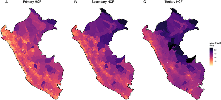
To better estimate the travel time to the most proximate health care facility (HCF) and determine differences across heterogeneous land coverage types, this study explored the use of a novel cloud-based geospatial modeling approach. Geospatial data of 145,134 cities and villages and 8,067 HCF were gathered with land coverage types, roads and river networks, and digital elevation data to produce high-resolution (30 m) estimates of travel time to HCFs across Peru. This study estimated important variations in travel time to HCFs between urban and rural settings and major land coverage types in Peru. The median travel time to primary, secondary, and tertiary HCFs was 1.9-, 2.3-, and 2.2-fold higher in rural than urban settings, respectively. This study provides a new methodology to estimate the travel time to HCFs as a tool to enhance the understanding and characterization of the profiles of accessibility to HCFs in low- and middle-income countries.
Gabriel Carrasco-Escobar
Assistant Professor
My research interests include infectious diseases epidemiology, causal inference, global health, Climate Change, Data Science, Urban Health, and Geospatial modeling & viz.